Just back from a great Barefoot Running class run by John Woodward and Janet Dutton. The highlight of the class was a beautiful run across the sands and tidal channels of the Duddon Estuary. It was Nelly's first time swimming! Tom Urry filmed us all running on pavement in running shoes and barefoot on the grass. (clearly the photo's not of me, but a better runner!)
A great group of people attended the class and we debated the conspiracy theories re shoe design, Vibram 5-fingers and the book "Born to Run" by Chris McDougall. Tales of incredible ultra-marathons from "Loony" Tom. In lectures, proto-bondage sessions with neoprene cuffs and bungee cords, we all practiced the movements that should have resulted in the perfect stride - with arched toes, landing softly on the forefoot, stroking the ground....Ahh, I know what I should do now... just have to do it!
The comparison of my normal heel strike with tense shoulders to the upright fluid form I had running barefoot. Click on the box and then triangle to see a 3 sec video.
I'm not sure I'm ready to throw away my trainers for my run on concrete across London every day, but I will work to try to land on my forefoot instead of my heels and hopefully avoid the Achilles pain that has been troubling me.
Billy, Nelly and I went on to have a glorious week walking in the Lake District despite occasional rain (a great excuse to explore new pubs...)
Sunday, August 16, 2009
Tuesday, August 04, 2009
Tutorial - How to upload a route to a Garmin 405 to use it for navigation.
This is pretty straightforward in the USA where topo maps are easily viewed in google maps and all the web-based applications that use them (e.g. MapMyRun.com).
But here in the UK, the Ordnance Survey topo maps are not accessible in Googlemaps. See the map on the left is the googlemap and the image in the middle is the OS topo map, and the right is the satellite image for the same area. Clearly, its hopeless to try to find a route to run on just the Googlemap or satellite maps - you need the right-of-way footpath info that is only found on the Ordnance Survey maps. The two images on the right are taken from a fantastic free (but donations accepted) web application Where's the path?
In this web accessed application, you just click on the little icon in the bottom left (next to the route length) and a route is marked on BOTH the OS topo and the sattellite image. When you're done just click on the import/export button and export the route GPX > File. Then you have to open another free site, GPSies Tracks for Vagabonds, and convert the GPX file to a Garmin Training Center TCX file format.
Once you have this file, you upload it on the Garmin Training Center program (which you have to download to your computer) and then you can then push the upload button to sync it to your 405. Its pretty useless that you can't upload routes to the web-based Garmin Connect site, but you can't. You can take a route that you or someone else has already run and do "send to device" to load it as a route, but not one from a map.
Once you've synced, on the Garmin 405, go to Menu/Training/Courses and select the one you uploaded and then "Do Course". Page through the displays until it has "to Course" and a compass rose on the screen and it will point the way to the start. Once you start, its a good idea to navigate back to this compass rose and lock the bezel. Then as you go along, it will show "dist to finish" when you're on course, and "dist to course" when you've strayed off - just follow the arrow (when you're moving). If you go seriously off course there's an alarm, and another beep when you find it again, and when you finish the course.

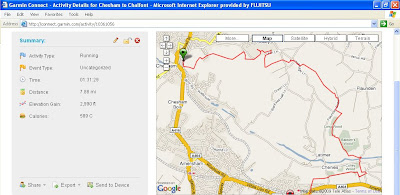
It really works! Here's the result of my navigating a path I picked to run between train stations near home seen in Garmin Connect and you can see under the "Map" tag, that I started going in the wrong direction, but backtracked until I found the route again. So for the continually lost-in-the-woods sort of person, this is a godsend!


